The Mystical Land of Punt
We are told that the....loading of the ships very heavily with marvels of the country of Punt;
"all goodly fragrant woods of God's-Land, heaps of myrrh resin, with fresh Myrrh trees, with ebony and pure ivory, with green gold of Amu, with cinnamon wood, khesyt wood, with two kinds of incense, eye-cosmetics, with apes, monkeys, dogs, and with skins of the southern panther. Never was brought the like of this for any king who has been since the beginning”
The identity of the Plants, Animals and products of the Land Of Punt has always remain a mystery but during the corse of the past few years and during the anylasis of the various inscriptions and mostly the walls mural of Hatshapsut and by studying the plants and animals and the gifted productes in more acuratly than what the earlear Archologists had.
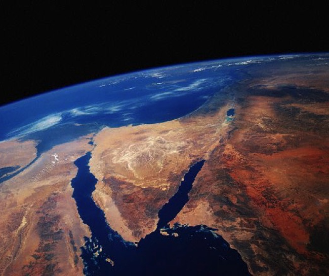
According to Sayyid al-Qimni, Egyptian historian and thinker in his massive four Volume Arabic books intiteled "Prophet Moses & The last days of Tell Al Amarneh" from page 239 - 363 suggests the Arbian Pennsula and particularly the region of south Jordan as the location of Punt Land.
Also according to Dimitri Meeks in a well researched paper called "Locating Punt" explain in 2011 how the hypothesis of an African location for the land of punt is based on extremely fragile grounds. He suggests Arabia for Punt location.
He explain:“The terrirtory of Punt began quite close to that of Egypt, once Sinai had been crossed, in Arabia Petraea or the Negev. It incoperate, probably in a rather imprecise manner, the whole coastal zone of the Red Sea dowen as far as present day Yemen and the actual heart of Punt probably correspond more or less to Yemeni Tihama."
Evidence from the ancients
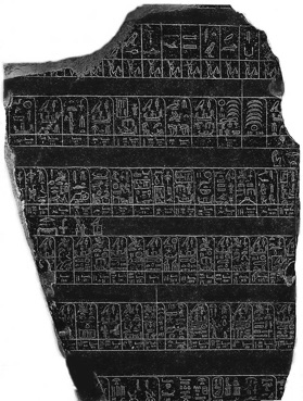
The first clear mention of Punt comes from the Old Kingdom. As the so-called Palermo Stone tells us, about 2500 B.C. during the reign of King Sahure, an expedition to Punt returned with 80,000 measures of 'ntyw, which scholars believe to be myrrh. Derived from a tree of the same name, myrrh is a resin used to make incense, which the Egyptians coveted for temple rituals; myrrh was the most prized commodity from Punt. Sahure's expedition also brought back 23,030 staves—wood being precious to a desert country like Egypt—and 6,000 measures of electrum, a natural alloy of gold and silver, among other items.
In the time of Pepi II, a certain pepynakht was entrusted with a delicate mission:
"so, His Majesty, my master sent me to the land of the Asiatics, so that i might bring him back the Unique Companion, the Captain (?), the overseer of interpreters Anankhta, who was assembling (sp) a kbnt-ship there in order to travel to Punt, when the Asiatic-dwellers-on-the-Sands killed him together with the armed detachment which was accompanying him." (Sethe 1903:134,13-14)
The scene of this tragedy can be seen at the coast of the Red Sea near the Asiatic dwellers on the sand where this person was killed while the assembling of the ship that was destined to sail to Punt. A location at the end of the gulf of suez would seem to fit best with the text. This clearly show that the scene of the tragedy must have been near Egypt and in a region Asiatic Bedouins.
By the Middle Kingdom, expeditions to Punt had become pyramidal in scope. One inscription from about 1985 B.C. mentions an expedition of 3,000 men; another a half century later boasted 3,700 men. Again, Punt's location is not given. Where did the ships go on the Red Sea after they set sail from Saww? No one knows.
Today, scholars have convincingly shown that Middle and New Kingdom pharaohs bent on Punt constructed their ships on the Nile, then disassembled them and carried them 100 miles across the desert from Koptos, the place where the Nile comes closest to the Red Sea. They then reassembled them at the ancient Red Sea harbor of Saww (today Mersa Gawasis) and sailed to Punt. On the return, they unloaded the ships at Saww and transported the goods by donkey caravan back to the Nile, where they loaded them onto other ships for the journey south to the capital at Thebes.
Actually the site of Mersa Gawasis “port” was very important port in the Middle Kingdom. Several stelae have been found there dating to the first half of the 12th dynasty contain references of Punt. From the quantity and coherence of these written sources, the amount of enigmatic objects/products and the aired and isolated nature of Mersa gawasis location indicate that this site was on one of the routes to and from Punt by boat.
The inscription also inform us that the voyages which were connected with “the mine of Punt” (pB n pwnt) rather than punt. (according to Gardiner 1952) and it seems that the location of this mine could have been at any point in the red sea coast. Many objects where found in this site including unfinished anchor, pegs, pieces of rope, along with fragments of copper alloy chisels.
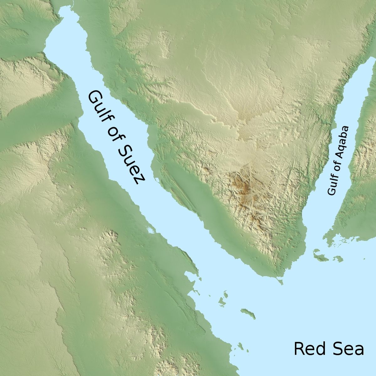
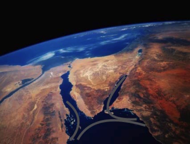
The site or port mersa gawasis seems to give the ancients the choice the outwards journey without problems. Because if the ship departed from a further north point from the Gulf of Suise hoping to reach the gulf of aqaba will not be able to make it. Because inexperienced Alius Gallus (Aelius Gallus was the 2nd praefect of Roman Egypt in the reign of Augustus during the years 26–24 BC.) attempted that rout and he lost his fleet ship and suffered serious damage to the rest of his fleet, from making the direct route round Ras Muhammad.
So all ships that left Egypt should land or sail towards the Arabian Pennensula some where between Aynunah and Jar in the south. From there ships could sail back up the Arabian coast in small stages, mostly rowing so as to reach the gulf of Aqaba intrace.
Whats interesting, one their return from the Gulf of Aqaba winds a currents would again carry the ships towards the Egyptian coast in the area of Mersa Gawasis.
The last expedition to Punt that we know of occurred under Rameses III, in the 12th century B.C. An ancient papyrus records that Rameses III "constructed great transport vessels ... loaded with limitless goods from Egypt. ... They reached the land of Punt, unaffected by (any) misfortune, safe and respected." And they returned safe and respected.
The details in Harris (Papyrus Harris collection in the British Museum) of an expedition sent by Ramsesses III to punt reinforce the impression that the northern end of this gulf of Suez, in all periods of the year, provide a favourable point of departure for long distance expedition.
Ramesses III (1186 to 1155 BC) writes regarding his expedition that he sent to Punt:“I built great ….which were equipped with countless crewmen. Landen with products beyond number from Egypt…(and then) sent to the great Sea of Nuqed, they reachhed the mountains of Punt without any misfortune befailling them ….”
Ramesses does tell us that they sailed on the “Great Sea of muqed” in order to reach Punt. Muqed is usually understood as two words, mw kd, meaning the revers water (the sea that flows backwards) which seems to mean the Sea that goes from south to North. Which allouds to the currents of the Gulf of Aqaba , which are the reserve current of the Nile.
Another important detail, Muqed appears in several series of toponym devoted to Syria-palestine, at Aksha, Amara and soleb. All these names were closly linked to Punt.
A Papyrus from the region of Ramsses IX confirms that this land was bordered by the sea, and it was inhabited by Shosu bedouin. And this lead us to Sinai with the Gulf of Aqaba coasts.
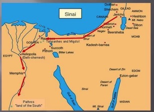
So in conclusion we do know many of the routes taken to reach punt. It could certainly be reached by boat from the Red Sea. During the Old Kingdom this involved crossing the desert east of Memphis to the Gulf of Suez, or Mersa Gawasis or setting off from the Sinai and then throught the so called King's Highway. And it sems that during the Middle Kingdom and afterwards, when the kingdom capital moved south, the Red Sea journey to Punt originated from the port of Quseir.


In 2004, archaeological excavations led by the Egyptologists Kathryn Bard and Rodolfo Fattovich at Mersa Gawasis in Egypt identified this harbor as the old port of Saww, which the ancient Egyptians used during their expeditions to Punt. The diggers found a number of commodities at the site that may have been brought back from Punt, including fragments of carbonized ebony wood (Diospyros sp.) and obsidian.

A 26th dynasty stela from Defenneh records how an expedition to Punt was saved from dying of thirst by unexpected rainfall in the mountain of the region. According to the text, the rain was linked to the floods of the Nile.
The question is to why a stela commemorating such an event should have been in North East Egypt ? It seems that the town was on the expedition to Punt route, for departure and return. And it points to a northern land route to Punt. Crossing to Sinai, passing by Serabit el khadim and then to Negev and then Punt.
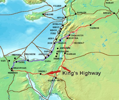
The King's Highway was a trade route of vital importance to the ancient Middle East. It began in Egypt, and stretched across the Sinai Peninsula to Aqaba. From there it turned northward across Jordan, leading to Damascus and the Euphrates River.
The Land of Punt ("Poont") is described in ancient Egyptian texts as "the land of the gods" and a region rich in resources. In the decades after Jean-Francois Champollion first deciphered Egyptian hieroglyphics in 1822 CE, and western scholars began reading Egyptian texts, questions arose as to where Punt was located and what it is called in the modern world.
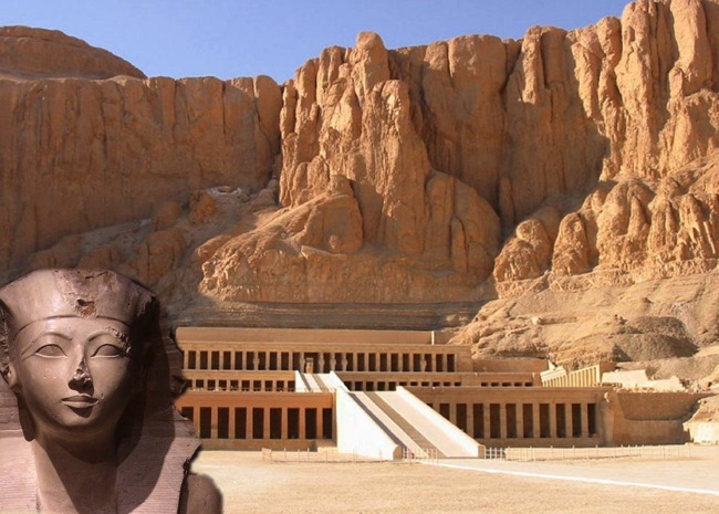
The country is best known for Queen Hatshepsut’s famous expedition in 1493 BCE in the 18th Dynasty of Egypt. This exchange between Egypt and Punt brought back living trees to Egypt, marking the first known successful attempt at transplanting foreign fauna. This voyage to Punt is only the most famous, however, and evidence suggests that the Egyptians were trading with the Land of Punt as early as the reign of the pharaoh Khufu in the Fourth Dynasty (c. 2613-2498 BCE) and probably earlier.
By the time of the Fifth Dynasty (c. 2498-2345 BCE) Egypt was flourishing through trade with these areas and especially the Phoenician city of Byblos and the countries of Nubia and Punt. Punt was not only a significant partner in trade, however; it was also a source of cultural and religious influence and a land which the Egyptians viewed as their place of origin and blessed by the gods.
The exact location of the Land of Punt is still disputed by historians, scholars, archaeologists, and others in the present day. Through the years it has been cited as part of Arabia, present-day Somalia at the Horn of Africa, the Sudan, Eritrea, or some other internal region of east Africa. The debate continues as to where Punt was located with scholars and historians on every side offering plausible supports for their claims.
Hatshepsut's inscriptions claim that her divine mother, Hathor, was from Punt and other inscriptions indicate that Egyptians in the 18th Dynasty considered Punt the origin of their culture.
Exactly why Punt was elevated from reality into mythology is not known but, after the reign of Ramesses III, the land receded further and further in the minds of the Egyptians until it was lost in legend and folklore. Yet, Punt remains a mystery to us even today, for we do not precisely know its actual location. It has been suggested that Punt, because of its exotic "overseas" character, might be as far away as Somalia, Yemen or even the Horn of Africa. However, many modern Egyptologists and other researchers place Punt much nearer to Egypt.
We will be investigating and exploring the true location of the Land Of Punt, by what the Egyptians had left us as documents, existing hieroglyphic texts, the expidition sent by Ramsesses III to Punt, and mostly from the expedition "expedition text" of the 18th Dynasty Queen Hatshapsut.
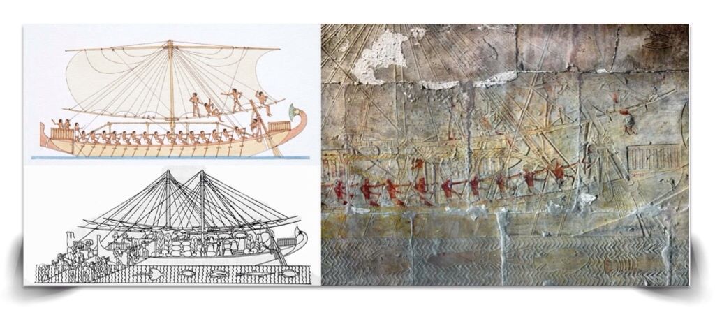
Queen Hatshapsut documented her expedition (Portico of Punt) at Deir El Bahri temple in Luxor (1473-1458 B.C), to this mysterious land. The voyage was undertaken in the summer of Hatshepsut's eighth year as queen. She sent (Senmut), her Chancellor, with a fleet of five ships that included thirty rowers each. Thier detailed depictions of the expedition on its second terrace, including the sea journey and even of the reception offered by the chief of Punt.